Bonii-Prep
v. 1.15bA motorcycle road rally spreadsheet
or a spreadsheet to export waypoints to a GPX file.
Contact: cpturner@turnlink.net
A spreadsheet application for Excel and LibreOffice that accepts bonus locations/waypoints, optionally encodes their map symbols, and exports a GPX file of waypoints that can be directly imported by Garmin BaseCamp, Mapsource, and other programs.
There are separate versions for Excel and for the free LibreOffice spreadsheets that each work with Macintosh and Windows systems.
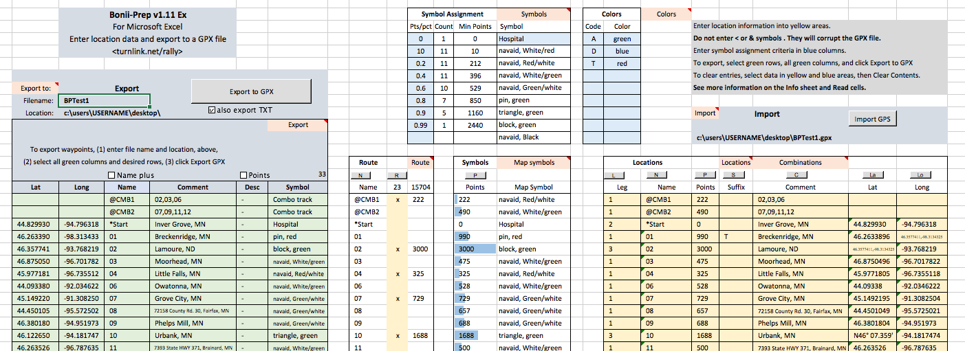
Similar to the EZ-Bake rally planning program, it includes specific features for efficiently entering and coding motorcycle road rally bonus location information including symbols, points, colors and coded names. Combinations of multiple locations are easily coded for display as a track line connecting locations.
Features include exporting GPX and text waypoint files with optional bonus point values. Of course exporting point values isn't very useful unless you can import them, so Bonii-Prep can import GPX waypoint files, including those with bonus points in the description field. This means that rally masters can produce GPX files with bonus points, and riders can use them without copy and paste.
All input, import, and export still takes place on one sheet for clarity. Transfer to a mapping program is a quick two step process, export/import of the GPX file.
Each download is a spreadsheet application with sample rally data entered.
Bonii-Prep is free to download and use.
For Excel, download Bonii-Prep v1.15b Ex
For LibreOffice, download Bonii-Prep v1.15b Lo
LibreOffice is available here.
For Custom symbols, download sample symbols
Features:
-- Exports waypoint and track information directly to a GPX file that can be imported by Garmin Basecamp and recent versions of Garmin Mapsource.
-- Works with recent versions of Excel and LibreOffice on Macintosh and Windows computers.
-- Option to export waypoint information to a text(.txt) file in addition to the .gpx file.
-- Export files (.gpx and .txt) can now optionally include location point values, leg values and suffix values.
-- GPX waypoint files can be imported directly into Bonii-Prep, including point values if present.
-- Combo definitions are easily entered so they appear in the mapping program as tracklines connecting locations.
-- Provides for exporting subsets of location waypoints.
-- Easy to keep track of all information on one sheet.
-- Scans for bad characters that can fail a Basecamp import and provides for correction.
-- Links to Google maps for each location.
-- Converts long/lat values to decimal degrees when entered in any common format, including with a comma as the decimal character.
-- Map symbol assignment is based on user specified point values and/or percentiles.
-- NEW... Support for groups of custom symbols and a method for changing from one group to another.
-- NEW... Sample sets of 60 custom symbols for Basecamp with Mac and Windows versions.
-- Assigned symbols and symbol colors can be overridden by individual location suffix codes.
-- NEW... Waypoint names can optionally be combined with point values and suffix field or point values and comment field for export.
-- Describes a method for obtaining and pasting in lat/long values from location descriptions.
-- Provides for totaling points when route locations are specified.
Version 1.15b: 7 May 2021
- Fixes an error condition when the combo point totals are greater than 32767.
- When the name has combo points attached to it for export, the total points for each location in the combo is now also exported.
Version 1.15a: 1 Feb 2020
- Fixes Name options not working in Lo version.
- Fixes code missing in Ex version cell D17.
Version 1.15: 13 Jul 2019
- Adds support for using groups of custom symbols and switching between groups.
- Adds sample sets of Basecamp custom symbols for Mac and Windows.
- Adds option to append the the suffix field or the comment field to the name and points for export.
Version 1.14a:
- Excel: Fixes "Get Locations" button on the Routes sheet.
Version 1.14:
- Scans for bad characters during export to a GPX file and provides for correcting them.
- Provides links to Google maps for each location.
- Fixes entry of lat/long values using deg/min/sec.
- Revises sample data to to better show common symbol assignment usage.
Version 1.13a:
- Changes symbol replacement suffixes to optionally either keep or remove the color when the symbol is changed.
- Revises guidance for Mac users of Excel when entering file paths for export/import. This returns support for Mac Excel v14 (Mac Office 2011).
Version 1.13:
- Adds optional Extended Content to include Leg and Suffix values in the exported GPX and TXT files. The Extended Content in GPX files imports properly into Bonii-Prep.
- TXT files are now formatted for easy copy/paste into Bonii-Prep, including Extended Content.
- Fixes the additional Route boxes on the Routes sheet so that they sort properly.
- Multiple small bug fixes and tweeks.
Version 1.12a:
- Increases maximum number of locations to 750.
- Fixes, again, improper symbol assignment and sorting behavior with large numbers of locations.
- Modifies GPX export file headers for compatibility with Basecamp when the file contains combo tracks.
- Drops support for Mac Excel v14 (Mac Office 2011). Use LibreOffice instead.
Version 1.12:
- Fixes improper Symbol Assignment behavior when there are more than 56 locations.
- Increases maximum number of locations to 500 with instructions for adding more.
- Adds ability to change assigned symbols, in addition to changing colors, with suffix codes.
- Lat/long values may be entered with either a dot or comma as the decimal character.
Version 1.11a:
- Fixes combo export when the combo definitions are not at the top of the location list.
Version 1.11:
- Adds an option to export waypoint information to a text(.txt) file in addition to the .gpx file
Version 1.10:
- Export files can now optionally include location point values.
- GPX waypoint files can be imported directly, including point values if present.
- Discontinued support for use with OpenOffice, however LibreOffice is also free.
Version 1.9:
- Provides for entering combo locations and displaying them as track lines.
Version 1.8a:
- Allows pasting lat/long values in the form lat,long into each column (i.e. paste, paste)
- Export filename and location are now entered on the spreadsheet in both versions.
Version 1.8:
- adds version for free OpenOffice and LibreOffice spreadsheet programs on Mac and Windows.
Version 1.7:
- adds suffix coding for symbol colors and name extensions.
- adds option for exporting waypoint names with or without extra coding.
- adds sort buttons on location columns.
- adds popup comments with additional information on program use.
Contact: cpturner@turnlink.net